
Create new streetlight network
Note: This guide assumes that
you have
successfully installed OMNeT++ and SUMO, and both tools are installed
at "C:\Users\user\scr".
Do
not process with this guide if you yet to import
StreetlightSim into OMNeT++.
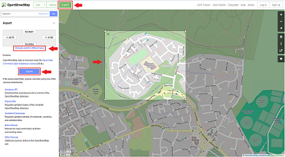
Step 1: Download the desired area of interest from OpenStreetMap
- Select the area of interest by click on the green "Export" button on the top left of the web page then the link "Manually select a different area" to define the size of the area of interest.
- Export the defined area by click on the blue "Export"
button on the left and save the data to "
<SUMO
root directory>\bin\
".
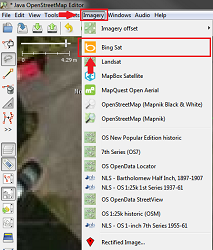
Step 2: Identify the streetlight locations using JOSM.
- Open the downloaded area of interest with JOSM and load the satellite image from Bing Sat by selecting Imagery-> Bing Sat from JOSM's menu bar.
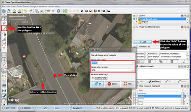
- Draw a polygon on the main road and normal to the actual streetlight geographical location. Then, set the values of the polygon as shown in the figure below.
 >
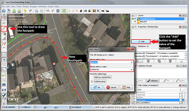
>Step 3: Add pedestrian footpath.
- Add the pedestrian footpaths using the draw tool. Then, set the values of these foothpaths as shown in the figure below.
Step 4: Generate the XML file for Streetlight locations and traffic routes.
Note: The xml file "typemap_building.xml" can
be found in StreetlightSim/AdditionalTools/SUMO.
This xml
file needs to be copied to "<SUMO
root directory>\bin\" before
"polyconvert" command
is executed.- In an OMNeT++ MinGW command
window, set the path of the command prompt to
<SUMO root directory>\bin\" - Run the command
"netconvert.exe --osm-files <OpenStreetMap_file_name>.osm -o <OpenStreetMap_file_name>.net.xml". - Run the command
"polyconvert.exe --net-file <OpenStreetMap_file_name>.net.xml --osm-files<OpenStreetMap_file_name>.osm --type-file typemap_building.xml-o <OpenStreetMap_file_name>.poly.xml".
Final step: Generate / Convert the XML into StreetlightSim Format.
sumo_file_gen.sh"
and "streetlightSimRouteGen.exe"
can
be found in StreetlightSim/AdditionalTools/SUMO and
StreetlightSim/AdditionalTools/streetlightSimRouteGen/bin/Release,
respectively. These tools need to be copied to "<SUMO
root directory>\tools\assign" before "sumo_file_gen.sh" is executed.
- Copy the
<OpenStreetMap_file_name>.osm,<OpenStreetMap_file_name>.net.xmland<OpenStreetMap_file_name>.poly.xmlfrom step 4 to "<SUMO root directory>\tools\assign".
- In an OMNeT++ MinGW command
window, set the path of the command prompt to
<SUMO
root directory>\tools\assign"
and run the command "sumo_file_gen.sh<OpenStreetMap_file_name><number of different paths>". For example,"sumo_file_gen.sh streetlight_map 10" will generate 10 different routes based on thestreetlight_map.osmfile. - All the necessary files for the new streetlight
network are located in "<
SUMO root directory>\tools\assign\OpenStreetMap_file_name".